8 favorite foliage hikes in Vermont
- Shelagh Hogan
- Oct 27, 2022
- 6 min read

Updated: Oct 7, 2023
About Conscious Travel Collective ~ Hey there! I’m Tara, the founder of CTC. After years in the travel industry and loving the opportunity to connect travelers with the world, I was struggling. Troubled by an important element I felt was sadly lacking. This element for me is what makes travel so special - real connection! Connection with places, through the people that live there. So, with much intention, I started Conscious Travel Collective to offer folks travel that connects, with luxury experiences at a reasonable price, with sustainability and ethical travel practices leading the way. Thanks for stopping by! For more on how we design trips for small groups, head over to our homepage.
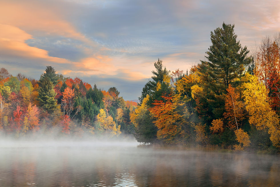
Vermont is a hiker’s heaven. With hundreds of trails strewn about the Green Mountain State, no matter what township you’re in, there’s a nearby path to lead you to peaks with breathtaking views, waterfalls, brooks, rivers, and covered bridges.
As we head into November and the New England foliage season is past its peak, I’ve rounded up some hiking routes for the most breathtaking autumn views in the great state of Vermont. Because really, it’s never too early to begin planning for next year’s fall foliage season.
When is the best time of year to peep the Vermont autumn colors?
The leaves begin changing in late September with autumn colors peaking around mid-October in most regions. Generally, mountain ranges will have colors changing sooner at higher elevations than the valleys.
If you have the time and are in the area for foliage season, plan to tackle the trails in the northern part of Vermont earlier in the season. Save hikes for the southern half of Vermont for mid-late October.
Vermont’s website has a foliage tracker to aid with your planning and serves the spontaneous weekend hiker well. Just remember that other leaf peepers are probably tracking the colors as well.
Below we have eight of our favorite Vermont hikes for viewing the autumn leaves on full display.
Best Vermont hikes for beginners
It’s not totally necessary to sweat for the fall color views, and maybe you’re just looking for a more relaxed experience. So, here are some hikes that are rated “easy” for effort, but still deliver the goods when it comes to Vermont foliage trails.

Camel’s Hump View Trail
This pretty little gravel loop in Duxbury, VT, is less than a mile long and has only 130 feet of elevation and its views of Camel’s Hump Peak are gorgeous during peak foliage season. Perhaps so enticing, you’ll be ready to lace up your hiking boots and take on the more challenging, but so-worth-it Camel’s Hump Trail. (See trails for ambitious hikers below).
Hamilton Falls Trail
Located in the town of Jamaica, Vermont, this easy-to-moderate trail is super popular— and for good reason. It’s a low elevation-gain route along the Cobb Brook and old railway, arriving at the charming Hamilton Falls a few miles and minimal elevation gain away. This six-mile round-trip hike is an easy favorite for the avid leaf-peeper, so you can expect to share the trail with others heading to the falls. Not up for a hike? There is limited parking available at the falls themselves.
Thundering Brook Falls
This cute little “hike” in Killington, Vermont is a popular one if you’re looking for a picturesque autumn nature walk to the waterfalls. The well-maintained boardwalk trail is easy to access from River Road and is also linked to the Appalachian Trail for those wanting to venture a little further.
Journey’s End Trail
This 3-mile out-and-back hike is best in the early foliage season and takes hikers from North Troy, Vermont to the Canadian Border. Take the Journey’s End trail for a quick day hike from North Troy and snap some pics of the Canadian Border monument in the foreground with some fiery foliage in the background.
Best Vermont foliage-peeping trails for ambitious hikers
These trails bring it all— more than adequate step counts, elevation gain, rocky scramble trail, and sublime summit vistas. These moderate-difficult foliage hikes are sure to challenge (and reward) even the more conditioned hikers.
Camel’s Hump Trail:
Arguably some of the most beautiful views once you’ve arrived at “the hump,” (read: summit) but also one of the most hard-earned. With a distance of over 6 miles, out-and-back, and over 3,000ft of elevation gain, Camel’s Hump Trail is not for the faint of heart.
It has a few narrow sections where you have to “scramble” on rocky trails, but oh man, are the views at the top worth it! Check out the autumn hues from the top of Camel’s Hump out as far as Killington Peak, Mount Washington to the east, and Mount Mansfield.
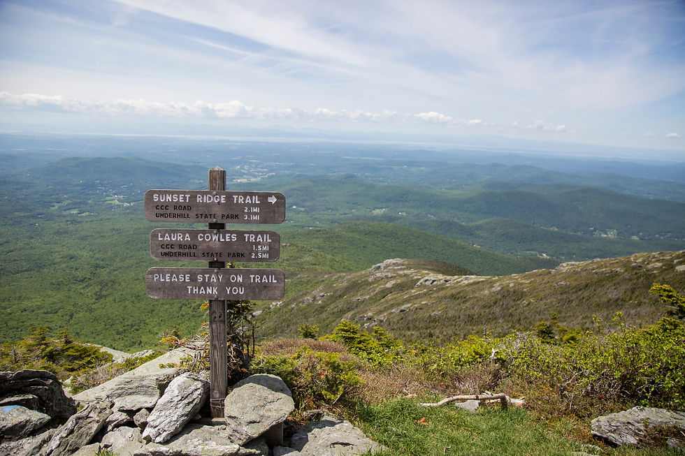
Mount Mansfield Loop Trail
The Mount Mansfield Loop Trail is a doozy of a hike, but its summit views are simply enchanting. What else could you expect from the highest mountain in the state? Located in the Green Mountain range, this trail takes you up, up, above the treeline to display the stunning canvas of maple and oak trees turning below. Beginning from the Civilian Conservation Corps Road at the Underhill State Park, take the route counterclockwise (trust us on this one) along the Maple Ridge Trail to Long Trail and later to the Sunset Ridge Trail. There are a couple of technical sections where some tolerable leaping and climbing are necessary, but when there’s a will there’s a way! And the views of Lake Champlain and the surrounding mountains from the top? Worth it.
Jay Peak Trail via Long Trail
This trail features some steep, rocky terrain that may pose a challenge for some hikers. The views at the top, however, are unbeatable. Follow the white trail markers for 3 miles, about 1,500 ft of elevation gain, and your effort will be rewarded with 360° colorful views of Westfield, VT, and surrounding areas.
Lake Willoughby-Mount Pisgah Trail
Distance: 4.1 miles out and back hike
It’s definitely a steeper hike than you’d expect, but the tranquil sights over Lake Willoughby and the long-range views are stunning. Loaded with orange and yellow maple trees turning and speckled with some red oaks, this trail is the perfect one for getting the most out of Vermont in peak season.
If you’re looking for a sustainable, quintessential Vermont experience during THE BEST time of year to visit, check out CTC’s once-a-year trip here.
Tips for hikers
✔ Proper footwear: Fall, my friends, is what you want to see, not what you want to do. These trails can get muddy and slick once the weather turns colder and fallen leaves line the path. Closed-toe athletic shoes with good treads (!!) and ankle support are a must for challenging climbs.
✔ Hydration: Many of these trails are several miles long and have significant elevation gain and when the weather gets cooler, you don’t think you’re sweating as much as in the summer months. You are. Take care of your body for maximum enjoyment and safety.
✔ Layers: It may be toasty down at the base of the trail, but you can bet it will be chilly (and windy) at the top. Bring a little day backpack to toss a couple of layers in as you hike. If you’re anything like me (a.k.a. A big baby when it comes to being cold) a pair of gloves and a second pair of socks are also highly recommended.
✔ Weather: Checking the weather conditions (both at the bottom AND the top of the trail) will greatly increase the odds of having a pleasant hike. While I’m all for the romance of a spontaneous fall road trip to Vermont to peep some leaves, you can bet I’m going to be annoyed if it’s miserable at the top of the trail.
✔ Leave No Trace As part of the Conscious Travel Fam, we know it pretty much goes without saying that you shouldn’t litter and you’re probably familiar with Zero Waste traveling tips (if not, you can learn more here). Pack it out if you brought it in, friends! And re-use or recycle it properly.
If you’re looking for ways to travel with more intention, subscribe to our mailing list, and follow Conscious Travel Collective on IG or FB. We craft private small group travel for those looking for meaningful connection to places and people, so when you are ready to experience for yourself, we are here help make it happen!
The author of this blog is the oh-so-talented, Shelagh Hogan.
You can find out more about her work on our team page


Comments